Saint Vincent (island)
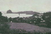 Villa, St. Vincent, 1890s |
|
 |
|
| Geography | |
|---|---|
| Location | Caribbean Sea |
| Archipelago | Windward Islands |
| Area | 345 km2 (133.2 sq mi) |
| Length | 18 mi (29 km) |
| Width | 11 mi (18 km) |
| Highest elevation | 4,048 ft (1,234 m) |
| Highest point | La Soufrière |
| Country | |
|
Saint Vincent and the Grenadines
|
|
| Largest city | Kingstown (pop. 19,300) |
| Demographics | |
| Population | 120,000 |
| Density | 347.83 /km2 (900.88 /sq mi) |
| Ethnic groups | Black 66%, East Indians 6%, Carib Amerindian 2%, Mixed Race 19%, White (including Portuguese) 4%, Other 3%. |
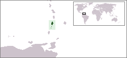
Saint Vincent is a volcanic island in the Caribbean. It is the largest island of the chain called Saint Vincent and the Grenadines. It is located in the Caribbean Sea, between Saint Lucia and Grenada. It is composed of partially submerged volcanic mountains. La Soufrière is still an active volcano .[1]
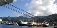
The territory was disputed between France and the United Kingdom in the 18th century, before being ceded to the British in 1783. It gained independence on October 27, 1979. Approximately 120,000 people live on the island. Kingstown (population 19,300) is the chief town. The rest of the population resides in the other five main towns of Layou, Barrouallie, Chateaubelair, Georgetown, and Calliaqua.
Contents |
People
The people of St. Vincent and the Grenadines are called Vincentians. Afro-Vincentians are the majority ethnic group (66%) and are the descendants of enslaved Africans brought to work on the plantations. There are also a few white descendants of English and French colonists, as well as a small number of Indo-Vincentians, descendants of indentured workers from India, and there is a sizable minority of mixed race (19%). The population of the island in 2008 was 118,000 and the annual growth rate is 0.5%. The main religions are Anglican (47%), Methodist (28%), Roman Catholic (13%), other Protestant denominations, Seventh-day Adventist, and Hindu. Adult literacy in 2004 was at 88.1%. Infant mortality in 2006 was 17 per 1,000 live births, and life expectancy for men stood at 69 years, with 74 years for women. The active workforce in 2006 was 57,695, and unemployment in 2004 was at 12%.[2]
History
See main article History of Saint Vincent and the Grenadines
Long before Christopher Columbus spotted this island during his third voyage in 1498, it had been called Hairoun by the Caribs. Columbus named the island St. Vincent, since it was discovered on 22 January, the feast day of the patron saint of Portugal, Vincent of Saragossa.
Geography of the island
Saint Vincent island is 18 miles long and 11 miles wide and is located 100 miles west of Barbados. It is dominated by the 4,048-foot-high, active volcano, called La Soufriere, which erupted violently in 1812 and 1902. The most recent eruption was on "Black Friday" [which was actually the Christian 'Good Friday' for that year], April 13, 1979. The island is mountainous and well-forested. Saint Vincent island belongs to the Lesser Antilles chain. Its territory has a total surface of 345 km², and the coasts measure about 84 km. The island is tropical humid, with an average of between 18 and 31 °C depending on the altitude.
Mainland St Vincent is one of the few places on Earth that can boast about having black-sand beaches and white-sand in the same country.
There are places where there is just a rock that borders the black-sand beach from the white-sand beach. The black sand, which was formed by the action of the volcano, is said to be able to provide one of the minerals that is needed by the human body. The majority of the beaches on the mainland have black sand (more than 95%), while all of the beaches in the Grenadines have white sand.
For many years the black sand was used in the building industry. During recent times, because of the destruction to the coastal areas, the government has restricted the amount of sand that can be removed from the beaches, and the beaches from which sand could be removed. This sand is still used in the construction of pitched roads, as it blends in nicely with the colour of the asphalt used for road construction.
Government and politics
The capital of Saint Vincent and the Grenadines is Kingstown. St. Vincent's government is a parliamentary independent sovereign state within the Commonwealth of Nations. The executive branch of government is divided in: the executive-governor general (representing Queen Elizabeth II, head of state), the prime minister (head of government) and the cabinet. The current prime minister is Dr Ralph E Gonsalves. The legislative branch of government is a divided 15-member elected House of Assembly and six-member appointed Senate. The judicial branch of government is divided into district courts, the Eastern Caribbean Supreme Court (High Court and Court of Appeals), with final appeal to the Privy Council in London. The parliamentary term of office is five years, although the prime minister may call elections at any time. The most important political parties are the New Democratic Party (Saint Vincent and the Grenadines) NDP and the Unity Labour Party (ULP).
Footnotes
- ↑ Rogozinski, Jan (1999). A Brief History of the Caribbean (Revised ed.). New York: Facts on File, Inc.. pp. 358–359. ISBN 0-8160-3811-2.
- ↑ "Saint Vincent and the Grenadines". U.S. Department of State. http://www.state.gov/r/pa/ei/bgn/2345.htm. Retrieved 2009-07-27.
See also
- 1898 Windward Islands Hurricane
References
- ↑ "Government of Saint Vincent". http://www.state.gov/r/pa/ei/bgn/2345.htm. Retrieved 2008-01-29.